

![]()
That can’t be a surprise, considering it’s the most remote place from any human civilization, and it’s buried under at least three miles of ice, almost five kilometers. It’s the coldest, highest, windiest, and driest place on the planet, making it nearly impossible for archaeological excavation and exploration without spending millions of dollars. No wonder we know so little about it.
Antarctica – A Tropical Paradise
The little we do know about it, however, is as surprising as ever. Fossil records reveal that millions of years ago, Antarctica was like a paradise – warm and covered in tropical jungles, forests, lakes, vegetation, and all sorts of wildlife.
This leads many to believe in the possibility that at some point in the distant past, Antarctica was home to Earth’s oldest civilization and that all the strange discoveries spotted there are scarce reminisce of its existence. Of course, scientists can’t dig the three miles of ice and explore it thoroughly, but does that mean that no one knows what lies beneath the ice?
The Piri Reis Map and Antarctica
Apparently not, because in late 1929, a German theologian working in Istanbul, Turkey, found a gazelle-skin parchment that had a map drawn on it. The map was from 1513 and was drawn and signed by an Ottoman admiral and cartographer by the name of Ahmed Muhiddin Piri, later known as Piri Reis.
It was very surprising that the map depicted North and South America with extreme detail. Although America was already discovered 21 years earlier, it was not mapped with such precision until much later. This made Piri Reis’s map the oldest surviving detailed map of the Americas. The map even depicted the Andes mountains, which were first sighted 14 years later by Francisco Pizarro.
What really shocked scholars was that the Piri Reis map also revealed the continent of Antarctica, and not only that, but it depicted it before it was covered with ice. No one could explain how this was possible, considering the fact that mainland Antarctica was discovered in 1820 and it was by then long covered with ice.
Apparently, Piri Reis didn’t create the map entirely by himself. Instead, he used the vast library of Constantinople, which was now in possession of the Ottomans. There, he uncovered different ancient maps from old civilizations like the Egyptians, Greeks, and Indians, together with six other sources Piri Reis didn’t want to disclose. From where these civilizations took the knowledge of the geography of Antarctica when it was without ice, and who the other six sources are is still a mystery.
Many people believe these civilizations received this knowledge from much older sources. Sources left from perhaps the first civilization that existed on the Earth. A culture living in Antarctica in a time when there was no ice and the continent was warm and full of life and vegetation.
Even if we assume that navigators sailed down the coast of America, Africa, and Antarctica to map it, then the Piri Reis map should indicate only the coastal features. Yet, the map accurately portrays mountains, rivers, and deep land features, which cannot be known without detailed exploration.
It was not until 2004 and 2007 when a detailed sonar radar surveyed Antarctica and scanned the topographical features of the landscape beneath the ice cap. Astonishingly, the Piri Reis map depicted all of these features beneath the ice.
Many people consider the map as evidence that an ancient advanced civilization existed millions of years ago and depicted Antarctica or that some kind of extraterrestrial contact brought this knowledge to the ancients.
Whatever the case, we may never know what really lies beneath the 3 miles of ice in Antarctica, but perhaps we don’t need to look under the ice. What if we look at the bottom of the sea near the coastline instead? What can we find there?
The Eltanin Antenna
In 1962, the National Science Foundation of the US created a technologically advanced oceanographic research vessel called the USNS Eltanin. It was the world’s first geophysical ship tasked with exploring Antarctica and the waters surrounding it.
In the next two years, the ship brought plenty of data previously unknown and shed much light on our knowledge of the region. There were, however, a few mysteries spotted at the bottom of the ocean.
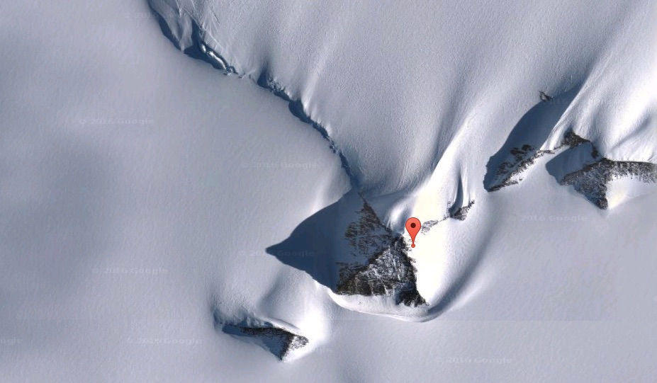
One of them was discovered on August 29, 1964, when the USNS Eltanin was photographing the ocean floor west of Cape Horn at a depth of almost 3 miles. What they discovered was astonishing. There, along the primarily bare bottom of the sea, they managed to take pictures of a bizarre structure standing in the middle of nowhere.
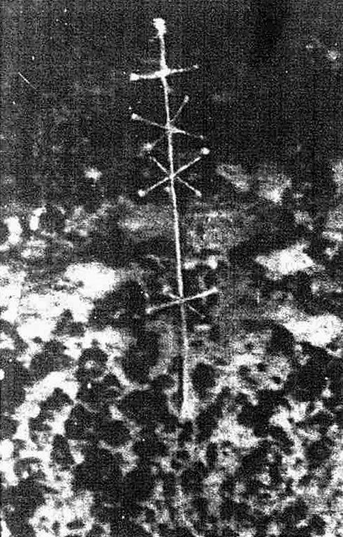
The structure was very symmetrical, standing at 2 feet high, and had nodules, spokes, and protrusions ending in a spherical node. It resembled an antenna or some other kind of signal transmitter.
When the New Zealand Herald first released the photographs on December 5, 1964, in an article titled “Puzzle Picture From Sea Bed,” scientists and researchers were immediately stunned.
The article read:
“The American research ship Eltanin sailed into Auckland yesterday with a mysterious photo taken at 2250 fathoms 1000 miles west of Cape Horn. The photograph, which to a layman shows something like a complex radio aerial jutting out of the mud bottom, was taken on August 29 by a submarine camera.”
The ambiguous object was eagerly discussed and debated for years, and thus the mystery of the so-called “Eltanin Antenna” was born.
What is the Eltanin Antenna?
Many people believed it was an out-of-place artifact left from an ancient civilization that once occupied the ice-free realm of Antarctica. They believe this civilization left many artifacts and remains of their structures under the 3 miles of ice now covering the continent. The seafloor near Antarctica is the only bottom not covered by ice; hence, we can find traces of their existence there.
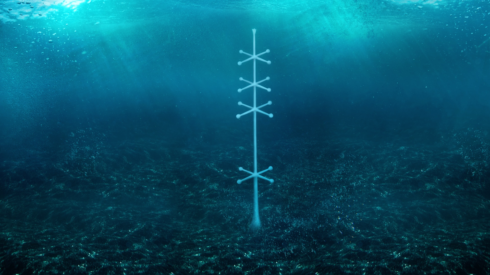
Others went one step further and believed the mysterious object was some sort of alien technology deliberately placed in such a remote and desolate location to emit signals for extraterrestrial communication and possibly planet surveying.
In 1968, author Brad Steiger stated in an article for Saga Magazine that the Eltanin had photographed
“…an astonishing piece of machinery… very much like the cross between a TV antenna and a telemetry antenna”.
Is the Eltanin Antenna a Sea Sponge?
Of course, scientists quickly tried to cover the story dismissing the discovery as an underwater sponge. They claimed what was photographed in the picture is the Cladorhiza concrescence – a sea sponge from the family of Cladorhizidae.
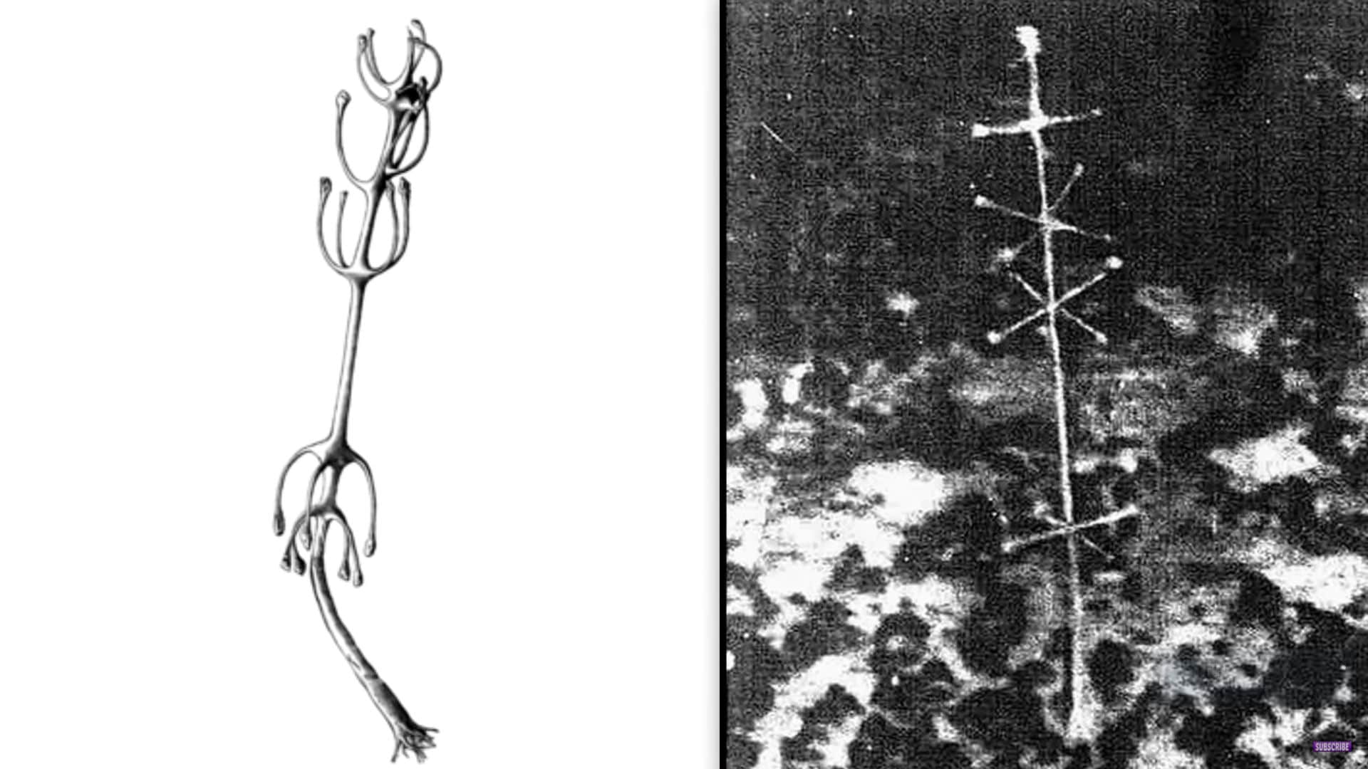
There are many problems with this theory. For instance, the so-called Eltanin antenna is very geometrical and has precise angels and formations, which can’t be said for the sea sponges to which it’s compared.
Another predicament with this hypothesis is that the Cladorhiza concrescence lives in colonies and quickly reproduces. This marine species possesses an asexual reproduction, which occurs when a small piece of the sponge breaks off and reattaches to the seafloor, forming nearly identical organism and eventually an entire colony. No such thing was found at the sea bottom as the object was standing all alone.
The third problem is that the picture taken from Eltanin was shot at a depth of exactly 2.5 miles or 4 kilometers. At that depth, no sunlight can reach the seabed making the existence of any sea sponges or plants highly impossible.
Dr. Thomas Hopkins, a senior marine biologist, specializing in plankton studies, also rejects the theory that the object is a plant.
In his own words:
“At that depth, there is no light, so photosynthesis could not take place, and plants could not live. I wouldn’t like to say the thing is man-made because this brings up the problem of how one would get it there… But it’s fairly symmetrical, and the offshoots are all 90 degrees apart. This is why it has been argued over for so long.”
But if the Eltanin Antenna is not natural and no man has the technology to install it in a depth of 3 miles, then who placed it there? And for what purpose?
The Purpose of the Eltanin Antenna
The authors and researchers Brad Steiger and Joan Whritenour may have an answer. They note that the Eltanin Antenna is placed precisely on the 45,000-mile fault line rift that encircles our planet. The fault line rifts are linear zones where the lithosphere (Earth’s outer part) is being pulled apart, creating extensional tectonics.
This leads them to believe that the device was placed there to measure important geodetic, geodynamic, and seismic activities from our planet. And whoever set it there was well beyond any human capabilities.
Steiger and Whritenour noted that:
“Our science does not yet possess underwater vehicles capable of descending to such depths; therefore, no one on Earth, that we are aware of, could have placed the device off Cape Horn…”
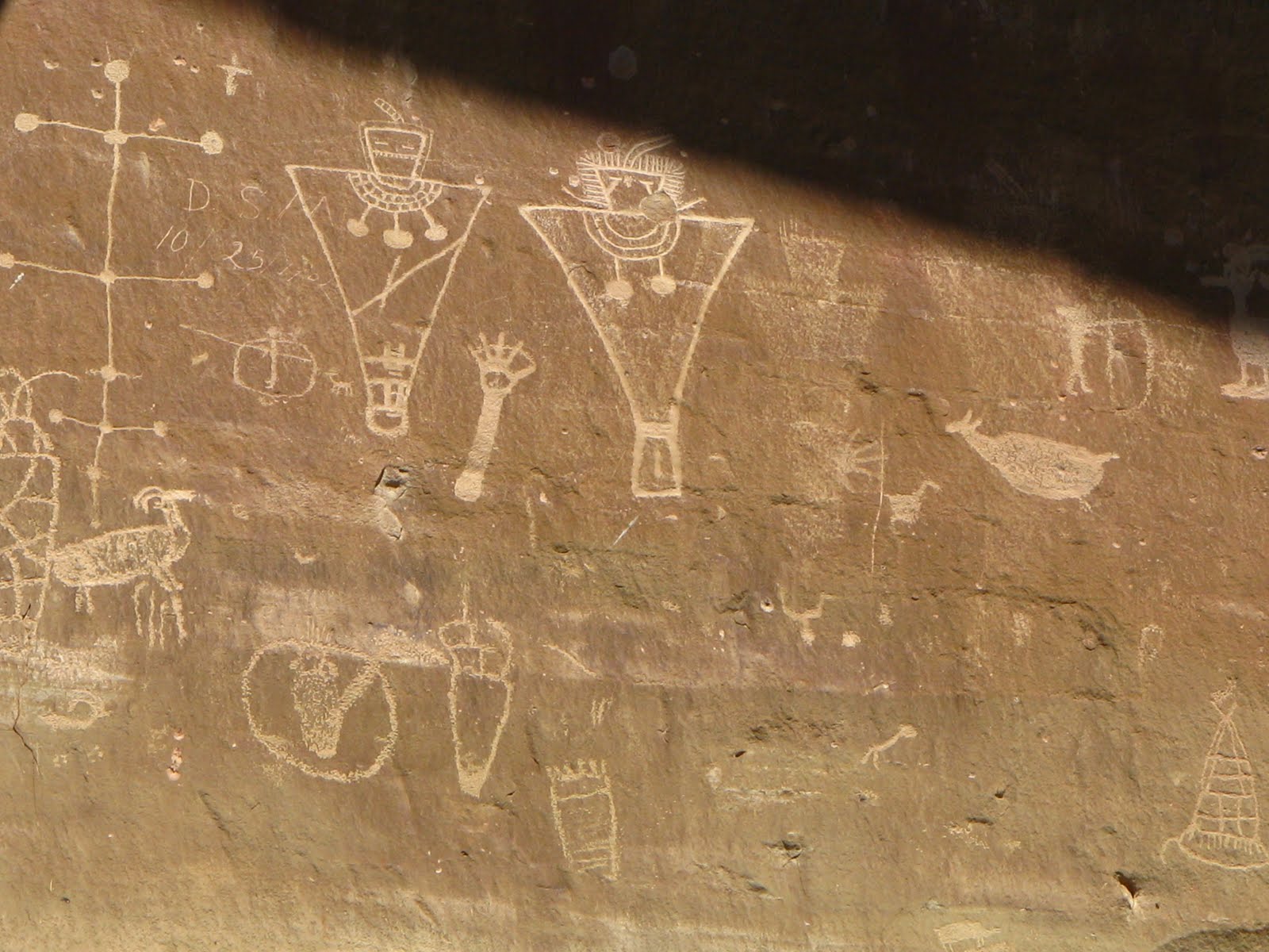
Interestingly, in the Sego Canyon in Utah, we can find this ancient petroglyph from 6000 BC, which depicts something very similar to the Eltanin antenna. Does this mean that the antenna has been on Earth for more than 8000 years?
The antenna is not the only thing depicted in the Sego Canyon petroglyphs, however. There, we can see these strange beings, clearly different than any human. They are very tall compared to the humans and animals next to them and have very strange and bizarre heads.
Are these beings responsible for the Eltanin Antenna?
Is it possible that an extraterrestrial civilization is observing us, placing different devices to measure our planet? And if they do, what other devices are out there, studying and surveying us?
Could the Black Knight Satellite be connected to the Eltanin Antenna in some way?
Please remember we all have different opinions, Think Before You Speak or Write Something that is cruel to Others. After all, We are only Humans. Wishing you clear skies and wide eyes. To share your experiences or just leave a comment there is a area below. Read or listen.
We are the change the world has been waiting for!
Have you witnessed an unidentified flying object?
You are not alone. Whether you think UFOs are black projects, extraterrestrial craft, something else altogether, or just don’t know, again, you are not alone!
Unconditional love. The road we all get to walk. Unconditional love is like the sun.
WE ARE THE DISCLOSURE !~ WE HAVE NEVER BEEN ALONE
Love and Regards,
Thank You,
Nancy Thames